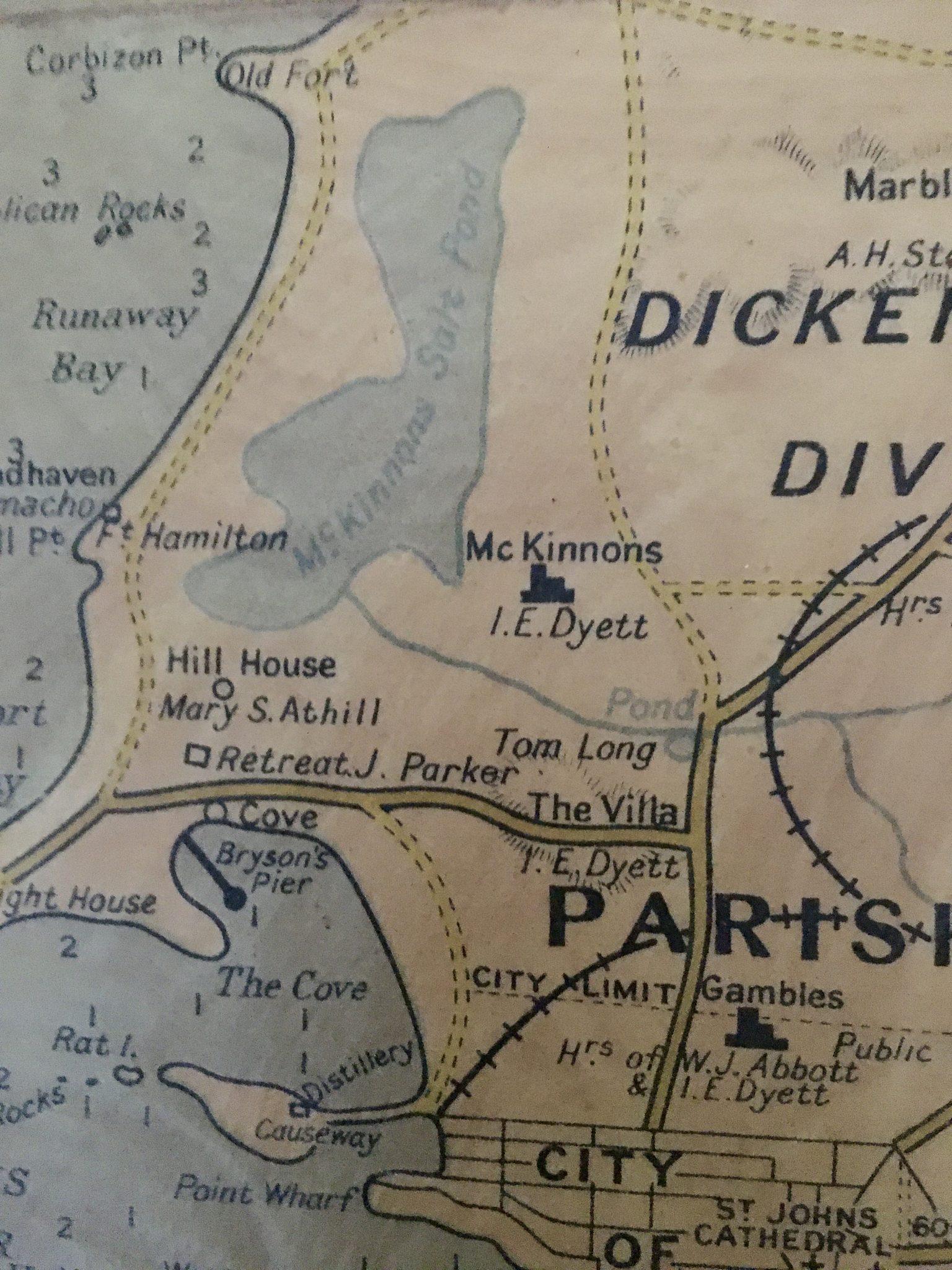
Where Was Mackinnon’s Estate?
Mackinnon’s Estate was located in Saint John Parish, in the northwestern part of Antigua, near the coastal area between St. John’s, Runaway Bay, Dickenson Bay, and the present-day McKinnon’s area. The Antigua Sugar Mills project identifies the Mackinnon site as a ruin in Saint John Parish, with a founding date in the seventeen hundreds. It also notes that the estate area looked west over McKinnon’s swamp, Dickenson Bay, and Runaway Bay.
The surviving wetland, usually called McKinnon’s Salt Pond or McKinnon’s Pond, lies on the west-facing coast of northwestern Antigua, around three kilometres north of St. John’s and just inland from Runaway Bay.
Geography of the Former Estate Area
The Mackinnon landscape sits in northwestern Antigua, close to the capital and the island’s tourist coast. Antigua itself is mostly low and undulating, with volcanic highlands in the west and a coastline broken by bays, headlands, reefs, and shoals. St. John’s, the capital, has a deepwater harbour, while the island’s low relief and lack of rivers make water management a recurring environmental issue.
The Mackinnon area is especially important because it connects several landscape types: former plantation land, modern residential development, coastal tourism zones, drainage channels, and a surviving salt pond wetland. McKinnon’s Salt Pond was once a mangrove-lined lagoon and is described as the largest natural pond on Antigua.
Mackinnon’s Estate as a Sugar Plantation
Mackinnon’s Estate formed part of Antigua’s plantation economy, which shifted toward sugar after English colonization. Antigua was colonized by English settlers in sixteen thirty-two, and by the later seventeenth century, sugar had become more profitable than tobacco.
The Mackinnon estate was associated with one McKinnon or Mackinnon family over several generations. The Antigua Sugar Mills project records ownership links beginning with Daniel MacKinnon in the seventeen hundreds, followed by William MacKinnon and later William Alexander Mackinnon. In eighteen twenty-nine, the estate is listed as belonging to “Messrs. McKinnon,” with eight hundred and thirty acres and two hundred and seventy-one enslaved people.
In an 1831 indenture, a part of the plantation in Saint John Parish and the Division of Dickenson’s was described as containing seven hundred and seventy-one acres, bounded by nearby lands and a highway.
Google Maps location of the MacKinnon Plantation in Antigua.
▶ open in Google Maps (17°08'25.1"N 61°50'55.7"W)In short
- 2 estates in detail
- One island, 108 square miles
- Two centuries of sugar
- One direct emancipation, 1834